


 Pro Benefits
 Σχετικά
 Όρους
Όρους
 Ιδιωτικότητα
 Child Safety & Protection
 Ειδοποιήσεις
 Ayrush Global It Services Pvt Ltd
Landscape Rendering Services: Transforming Ideas into Stunning Outdoor Visuals
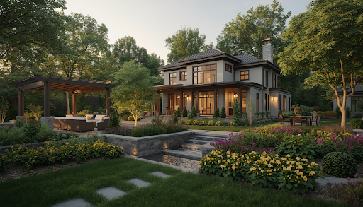
3D landscape rendering allows for the creation of an image that reflects reality. It may include greenery, hardscape elements, light points, and other landforms used in landscaping. Landscape visualizations are beneficial for landscape designers. This is because they can visualize the design of the site and ensure the layout before construction begins. Homeowners and business property teams can use it as a marketing tool.
3D Landscape Rendering: What Does It Entail?
It is the process of taking a 2D image or plan and transforming it into a 3D model of an outdoor space. The final product is a realistic image of how the completed project will look and feel. Using this type of rendering makes it easier to convey the property's intended new look.
A rendered landscape image differs from a 2D site plan in its ability to represent scale. This means that a client will know what a rendered deck or other structure looks like. This type of rendering helps to create stunning outdoor visuals and prevent design and communication errors.
How Does 3D Landscape Visualization Differ From 2D Site Plans?
A 2D site plan communicates measurements from above. A 3D landscape design visualization communicates how a space will actually feel at ground level.
|
Feature |
2D Site Plan |
3D Landscape Rendering |
|
Viewing angle |
Overhead only |
Ground-level and aerial |
|
Materials shown |
Symbols/labels |
Textured, true-to-scale |
|
Plant maturity |
Not shown |
Can simulate growth over time |
|
Light conditions |
Not shown |
Day, dusk, and night variations |
|
Best for |
Permits, layout math |
Client approval, marketing |
Why Do Landscape Architects Use 3D Rendering Services?
Landscape architects make use of rendering to devise a solution to a potential problem before construction. By being able to make realistic previews of the project, designers may choose what elements to implement without any expensive mock-ups. By utilizing such services, contractors can provide an impressive image of the final result for a landscaping project.
According to industry sources, the American market for landscape designs has witnessed a steady increase in recent years. This is due to a growing tendency to regard visualization as an integral part of the design process. Not only that, rendering allows landscape design companies to rely on extensive databases with digital plants.
What Elements Can a Landscape Render Include?
A complete outdoor space visualization typically layers several design elements together:
-
Landform and elevation - hills, slopes, and drainage systems
-
Green planning - botany, green plants, and seasonal varieties
-
Notable structures - flooring, pavements, retaining walls, and terraces
-
Water bodies - swimming pools, fish ponds, and fountains, including reflections
-
Lighting schemes - daytime, twilight, and night schemes
What Software Do Landscape Rendering Studios Use?
Professional studios, such as SMA Archviz, rely on established 3D tools for landscape rendering services rather than basic drawing software. This is because realism depends on lighting and material engines.
|
Software |
Primary Strength |
|
Lumion |
Natural effects—wind, weather, seasonal change |
|
V-Ray |
Photorealistic lighting and reflections |
|
Enscape |
Real-time walkthroughs during design review |
|
SketchUp |
Fast 3D modeling from 2D or CAD imports |
|
Revit |
BIM-based modeling for larger site plans |
How Do You Get 3D Landscape Rendering?
The process is similar for all residential and commercial jobs:
1. Provide us with your base plan - the site plan, hand-drawn or CAD file
2. Let's discuss the design direction - plant types, styles, materials
3. Review a 3D draft - It will show you the layout, grade changes, and features
4. Adjust the lighting - day or night, seasonal changes
5. Approve the final renders - large high-resolution files are ready to go
Conclusion
3D landscape rendering removes much of the guesswork from outdoor projects. The 3D renderings make the job for landscapers and architects much easier by minimizing the risk of expensive grading errors. It does so by providing a realistic picture for clients. For homeowners, on the other hand, 3D images are an effective way to showcase a property's outdoor space to potential buyers.
 Greek
Greek
 English
 Arabic
 French
 Spanish
 Portuguese
 Deutsch
 Turkish
 Dutch
Dutch
 Italiano
 Russian
 Romaian
 Portuguese (Brazil)
