

How Emergency Vehicle Service Apps Handle Location Sharing Now
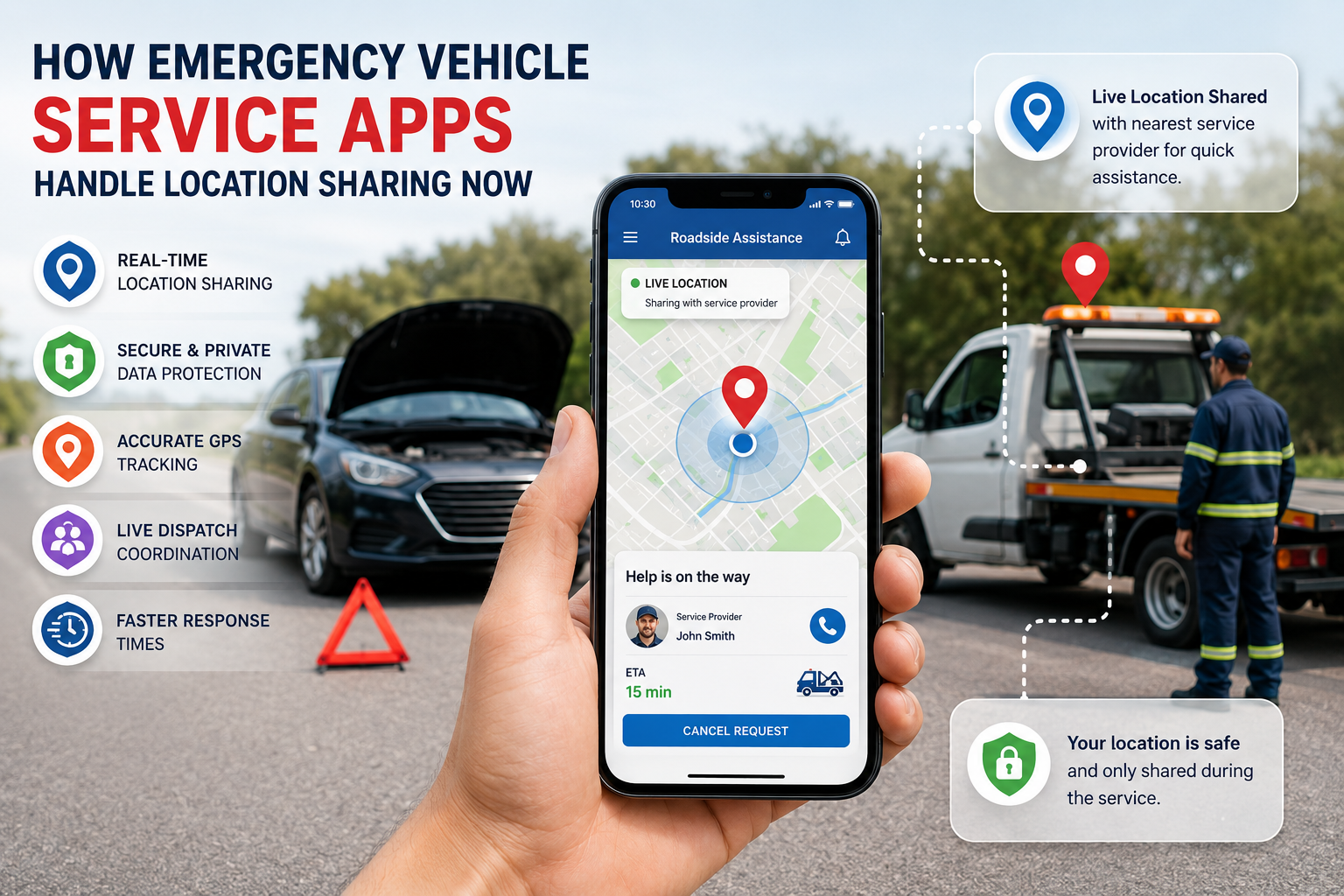
Emergency vehicle service applications have transformed the way drivers receive help during roadside emergencies. Whether a vehicle experiences a breakdown, a flat tire, battery failure, or an accident, these platforms enable users to connect with service providers quickly and efficiently. One of the most critical technologies behind this convenience is location sharing. Modern applications use advanced geolocation systems, real-time tracking, and secure data transmission to ensure that assistance reaches the correct location without delay. As technology continues to evolve, location-sharing capabilities are becoming more accurate, secure, and intelligent than ever before.
Current Statistics Highlighting Growth in Emergency Service Apps
The growing demand for digital roadside support has accelerated the adoption of emergency vehicle service applications worldwide. Several industry reports indicate significant growth in location-based assistance technologies.
-
More than 80 percent of smartphone users regularly enable location services for navigation and emergency-related applications.
-
GPS accuracy in modern mobile devices can often identify locations within a few meters under favorable conditions.
-
Connected vehicle technologies are expanding rapidly as automakers integrate telematics systems into new vehicles.
-
Emergency response times can be reduced substantially when real-time location data is automatically shared.
-
The global market for connected mobility and vehicle assistance technologies continues to grow steadily due to increasing vehicle ownership and smartphone penetration.
These trends demonstrate why location sharing remains one of the most valuable features in modern emergency vehicle service solutions.
How Location Sharing Evolved Beyond Basic GPS Tracking Systems
In the early stages of mobile applications, location tracking primarily depended on basic GPS coordinates. While effective, this approach often struggled with signal interruptions, inaccurate positioning, and delayed updates.
Modern systems have evolved considerably. Today's applications combine multiple technologies, including GPS satellites, cellular network triangulation, Wi-Fi positioning, and sensor-based movement detection. This layered approach creates a more reliable location-sharing experience, even in challenging environments such as underground parking facilities, dense urban areas, or remote highways.
The evolution of tracking technologies has also improved user convenience. Instead of manually describing their location, users can now share precise coordinates automatically. This capability minimizes communication errors and allows emergency service providers to locate stranded drivers faster.
For businesses investing in roadside assistance app development, advanced location technology has become a core requirement rather than an optional feature. Accurate positioning directly impacts service quality, customer satisfaction, and operational efficiency.
Advanced GPS Integration Improving Emergency Response Accuracy
GPS remains the foundation of location-sharing systems, but modern emergency vehicle service applications utilize it far more intelligently than before.
Current platforms continuously collect location data while optimizing battery consumption. Sophisticated algorithms determine whether a vehicle is stationary, moving slowly, or traveling at highway speeds. Based on these conditions, the application adjusts update frequency to balance accuracy and device performance.
Several enhancements improve GPS effectiveness:
-
Assisted GPS technologies that combine satellite and cellular information.
-
Dynamic route calculations for service providers.
-
Geofencing capabilities that trigger alerts when vehicles enter specific zones.
-
Automatic location refresh intervals during emergency requests.
-
Multi-source positioning for improved reliability.
These capabilities ensure that roadside assistance teams receive precise and continuously updated information throughout the service journey.
Another significant advancement involves predictive positioning. If GPS signals become temporarily unavailable, the application can estimate movement patterns based on recent travel history and sensor inputs. This feature helps maintain continuity during critical service requests.
Privacy Controls Shaping Safer User Location Sharing Practices
As location-sharing technology becomes more sophisticated, privacy concerns have gained increased attention. Users expect emergency assistance applications to provide convenience without compromising personal information.
Modern platforms address these concerns through multiple security measures. First, location sharing is typically activated only when necessary. Users often retain control over when their location is transmitted and who can access it.
Key privacy-focused practices include:
-
End-to-end encryption for location data transmission.
-
Temporary storage of active emergency session information.
-
Permission-based access controls.
-
Limited data retention policies.
-
User consent mechanisms before sharing location details.
Many applications also allow users to disable tracking immediately after service completion. This approach ensures that continuous monitoring does not occur unnecessarily.
Developers working on how to develop roadside assistance app solutions increasingly prioritize privacy-by-design principles. Integrating security features from the earliest development stages helps build trust while complying with evolving data protection regulations.
Real Time Coordination Between Drivers and Service Teams
One of the most valuable aspects of location sharing is its ability to facilitate seamless coordination between multiple participants during an emergency event.
When a driver requests assistance, location data is transmitted to a centralized platform. Dispatch systems analyze the information and identify the most suitable service provider based on proximity, availability, and required expertise.
The process typically includes:
-
Automatic location capture from the user's device.
-
Dispatch center verification.
-
Assignment of a nearby service vehicle.
-
Continuous route optimization.
-
Real-time arrival updates.
This level of coordination benefits both drivers and service providers. Drivers gain visibility into estimated arrival times, while technicians receive accurate navigation guidance.
Location sharing also reduces the likelihood of failed service visits. In the past, service teams frequently struggled to locate customers due to incomplete directions or communication challenges. Real-time mapping technology largely eliminates these issues by providing continuously updated positional data.
These operational advantages contribute significantly to the overall success of modern roadside assistance app development initiatives across the transportation sector.
Artificial Intelligence Enhancing Location Data Interpretation
Artificial intelligence is increasingly influencing how emergency vehicle service applications process and utilize location information.
Rather than simply displaying coordinates on a map, AI systems analyze contextual information to generate actionable insights. For example, machine learning models can evaluate traffic patterns, weather conditions, road closures, and historical response data to recommend optimal service routes.
AI-driven features include:
-
Intelligent technician assignment.
-
Predictive arrival time estimation.
-
Automated incident categorization.
-
Traffic-aware route optimization.
-
Location anomaly detection.
These capabilities improve operational efficiency while enhancing the customer experience.
Artificial intelligence can also help identify potentially dangerous situations. If a vehicle remains stranded in a high-risk area or experiences unusual movement patterns, the system may trigger additional alerts or prioritize dispatch actions.
As emergency service platforms continue to evolve, AI will likely become an even more important component of location-sharing infrastructure.
Key Challenges Affecting Reliable Location Sharing Performance
Despite substantial advancements, location-sharing systems still face several technical and operational challenges.
One common issue involves signal limitations. Rural regions, mountainous terrain, tunnels, and underground facilities can interfere with GPS reception. Although multi-source positioning helps mitigate these problems, complete accuracy cannot always be guaranteed.
Additional challenges include:
-
Inconsistent network connectivity.
-
Device hardware variations.
-
Battery limitations during prolonged emergencies.
-
Privacy and regulatory compliance requirements.
-
Environmental interference affecting positioning accuracy.
Application developers must carefully address these obstacles when designing robust location-sharing systems.
Organizations evaluating the cost to build roadside assistance app platforms often discover that advanced location technologies represent a significant portion of development expenses. Features such as real-time tracking, route optimization, geospatial analytics, and secure data infrastructure require specialized expertise and ongoing maintenance.
Balancing accuracy, performance, and cost remains a critical consideration throughout the development process.
Emerging Technologies Transforming Future Emergency Navigation
The future of location sharing extends far beyond conventional GPS tracking. Emerging technologies are creating new opportunities for faster and more intelligent emergency assistance services.
Connected vehicles equipped with built-in telematics systems can automatically transmit diagnostic information alongside location data. This allows service providers to understand the nature of a vehicle problem before arriving on site.
Other innovations include:
-
Vehicle-to-infrastructure communication.
-
Satellite-based connectivity enhancements.
-
Edge computing for faster data processing.
-
Augmented reality navigation support.
-
Advanced telematics integration.
A growing number of organizations are also exploring the adoption of a white label roadside assistance app model. These solutions allow businesses to deploy customized service platforms while leveraging existing technology frameworks that already support advanced location-sharing capabilities.
As these technologies mature, emergency response systems will become increasingly proactive rather than reactive. Future platforms may detect vehicle issues automatically and initiate assistance workflows before drivers even place a service request.
Conclusion
Location sharing has become the foundation of modern emergency vehicle service applications. Through the combination of GPS, cellular networks, artificial intelligence, and real-time communication systems, these platforms provide faster and more reliable support for drivers facing unexpected roadside situations. Continuous improvements in accuracy, privacy protection, and predictive capabilities are reshaping how emergency assistance is delivered. As connected mobility technologies continue to advance, location-sharing systems will play an even greater role in improving safety, reducing response times, and creating a more efficient roadside support ecosystem for drivers around the world.
